
Language is arguably the most important of the cultural universals. This is not to question the significance of religion or other traits; but language is essential to communicating and sharing many aspects of culture. The standard first step in analyzing the geography of languages is to produce a map of them. For example, Figure 1 shows a map of where English is the primary language.
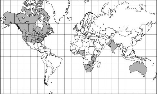
As shown in Figure 1, in Britain, Australia, New Zealand, Canada, and the United States, English is spoken by the overwhelming majority of the population. In other countries, English is spoken only by a minority, even though it may be an "official language." The "big picture" map aside, consideration of language affords opportunity to observe and apply diverse concepts of cultural geography.
Diffusing languages
The map of English-speaking countries is in large measure a product of cultural diffusion from Britain through its former colonies. The initial stage was largely limited to relocation diffusion. That is, large numbers of immigrants and officials moved from Britain to the colonies and, of course, took their language with them. Once there, they intermingled to different degrees with native peoples and non-English speaking immigrants, many of whom acquired English by contagious diffusion — contact with English speakers.
English now enjoys the status of official language — the one in which government business is transacted and printed, as well as the language of publicly financed education — in virtually all of Britain's former colonies. In many cases, it is also the vernacular language — the one that is spoken by the people of a particular locality. But official and vernacular languages are not always the same in a given area or region. English, for example, is the official language of the United States and most Americans speak it, but literally millions of people living in ethnic neighborhoods, Indian reservations, and other enclaves across the land speak a different vernacular language. Look again at Figure 1 and you may get the impression that everybody in the United States, Australia, and New Zealand speaks English. Not so. People in parts of each country speak a different vernacular language.
Many countries that are former colonies have adopted the language of the colonizer as their official (or co-official) tongue even though, in many cases, only a minority of the populace speaks it. Examples include English in Ghana and Kenya; French in Senegal and Madagascar; and Portuguese in Angola and Mozambique. Typically, European languages are given official status in the former colonial realm for two reasons:
- The country contains numerous ethnic groups, some of which have a history of friction. Elevating one local language to official status could lead to jealousy and unrest on the part of other groups. Use of a European tongue favors no one and, in effect, puts everybody at an equal disadvantage.
- Use of a European tongue stands to promote international trade and commerce more than would a local language, which may be spoken nowhere else on Earth.
Nevertheless, many (even most, in some cases) of the native peoples in these countries continue to speak their own tongue as the vernacular language. In most cases, use of the official language(s) is concentrated in the cities and larger towns, while the vernacular persists in the smaller towns, villages, and rural areas. To the extent that everyday use of the official language is gradually "trickling down" from urban to rural areas, its spread exemplifies the process of hierarchical diffusion.
Checking the physical effects
Language and physical geography may interact in various ways. The two most significant ways are through environmental terminology and linguistic refuges.
Environmental terminology
Languages tend to develop robust vocabularies that pertain to locally observed environmental conditions, and weak vocabularies that pertain to unfamiliar settings. English, for example, is weak in native terminology that pertains to deserts, the sub-arctic, very mountainous areas, and other characteristics that are not common to England. Thus, English has adopted environmental terminology from other languages to describe things that English cannot, or at least not very well. Accordingly, standard English dictionaries now include terms such as arroyo (from Spanish) to describe intermittent streams in desert environments, taiga (from Russian) to describe high-latitude coniferous forest, and fiord (from Norway) to describe steep-sided, glacially carved inlets of the sea.
Linguistic refuges
A linguistic refuge is an area where a language is insulated against outside change by virtue of remoteness, or the remains of a locale where a once widespread language continues to be spoken. Acting as physical barriers, aspects of the physical environment have served to isolate speakers of various languages and thus preserve their native tongues from outside agents of change. Heavily forested and extremely mountainous areas have historically served that purpose.
The traditional Welsh and Irish languages, for example, at one time appeared to be on the brink of extinction, relegated to remote peninsulas, islands, and valleys in their homelands following the onslaught of English. However, nationalist aspirations and heritage awareness have led to campaigns to resuscitate these languages and promote their everyday use. Central to these efforts have been human resources — native language speakers — many of whom hail from villages and farms in linguistic refuge areas.
Playing the landscape naming game
Language may provide cultural character to the physical environment as well as to people. For example, what do New Jersey, Lake Okeechobee, Baton Rouge, and El Paso have in common? The answer is they are all toponyms orplace names. People the world over have a habit of naming landscape features, be they mountains, hills, rivers, lakes, bays, seas, deserts, forests, cities, towns, streets . . . the list goes on and on. Toponymy, the study of place names, may provide diverse geographical insights. As per the four locales mentioned, toponyms may tell us something about where the settlers came from, who used to live here, and what language the settlers spoke. Toponyms may also tell us something about past religious distributions. Catholic settlers in North America, for example, had a propensity to bestow religious names on their settlements more so than Protestants, no doubt in part to solicit the protective favor of the Almighty in an often-difficult frontier setting. Thus, towns named for saints abound, especially in Quebec and California (San Diego, Santa Barbara, San Jose, San Francisco, and so on).
Place names may also provide philosophical insights. For example, about two centuries ago American culture was affected by the Classic Revival, which involved a new reverence of ancient Greece and Rome. One manifestation is the existence in Upstate New York of literally dozens of cities and towns that were named or renamed in accordance with the classical theme. Examples include Syracuse, Rome, Utica, Ithaca, and Romulus.
One of the most maddening things about toponyms is that they can be literally changed overnight, immediately rendering millions of maps and atlases out-of-date. The change of Burma to Myanmar and Zaire to Congo are fairly recent examples. Prior to its dissolution, the USSR contained an estimated 20,000 places named for Stalin — mountains, cities, alleys, you name it (literally). When Stalin's legacy suddenly fell out of favor, so did toponyms in his honor. Few remain.